Track History
Interesting Facts
British sovereignty was first proclaimed by Captain Cook and the flag formally raised on the summit of Motuara Island on 31st January 1770.
Within Resolution Bay is Schoolhouse Bay, which was once the site of the local school. At one time children from the neighbouring farms walked or rode their ponies to school along the bridle paths which now form the basis of the Queen Charlotte Track.

Until the end of the 19th century there was a thriving township at the head of Endeavour Inlet. Antimony was mined there and at one time sailing ships loaded their cargoes in the Inlet before sailing direct to England with the valuable metal.
Legend tells of the early Maori using Torea Saddle to haul their canoes from one sound to another.
Early pioneering farmers planned to create a canal across the Te Mahia Saddle as a quick route to Picton for transporting wool and livestock.

List with us
Drive website traffic to your business. Add your accommodation, transport or activity listing to our website.
Track History
The Queen Charlotte Walkway and the surrounding area is part of the special history of the Sounds. The track itself is based on a network of pioneer day bridle paths – a humble beginning for what has become such an outstanding walking track in New Zealand.
For at least 800 years Māori have occupied the Sounds. Totaranui (the Māori name for the Queen Charlotte Sound) was an important area for them. The sheltered Sound was used for travel and provided bountiful seafood for the many Maori who lived there from the sheltered inlets, together with birds, has sustained their developing culture.
Evidence of their seasonal camps, permanently occupied villages and fortified pa can still be seen throughout the area. All historic sites in the area, both Māori and European, are protected.
The outer sounds are also associated with the renowned Polynesian explorer Kupe. Many place names in this area commemorate his exploits. The carved pou whenua (pole) at Meretoto/Ship Cove illustrates the legend of Kupe and the giant wheke (octopus). The carved bollards at the bridge at Meretoto/Ship Cove signify the iwi of the area.
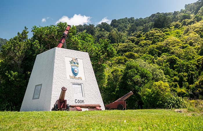
It was at Ship Cove, in 1770, that the first sustained contacts between Māori and Europeans took place. Captain James Cook was the first European to set foot ashore in the Sounds, even though Abel Tasman had previously visited the area in 1642. Cook anchored in Ship Cove, a place of endearing beauty and he stayed there five times between 1770 and 1777 and this tranquil retreat has remained virtually unchanged from that time. He gave the name of ‘Queen Charlotte’ to the Sound, named after the wife of King George the Third.
Since that time, the area has been the scene of a diverse range of activities from gold and antinomy mining, whaling and fishing through to tourism and forestry leaving the Queen Charlotte Sound and its immediate area full of interesting history.
Development of the Queen Charlotte Walkway
The Queen Charlotte Walkway has been in development, as a public walkway, since the early 1980’s. After initial work by local landowners to create a walk-able track from 1981 – 1983 a rough walking track was opened for the public to use in early 1983.
Prior to this a series of unconnected tacks already existed in the region but were used mainly for things as transporting goods and moving stock on the Coastal tracks while the tracks north of Kenepuru were used for coast watch during World War II.
In 1985 government funding stopped and so too did the maintenance of the track. Cattle were grazed on the track from Kenepuru Saddle to Black Rock Station but local landowners continued with their efforts to up keep the hard work of mowing Kenepuru Ridge and keeping possum and pig numbers down.
With the formation of the Department of Conservation (DOC) in 1987 the maintenance of the track was taken over by the Department. Two years of gorse had taken its toll on the track and DOC enlisted the help of the New Zealand Air Force to assist in a major clean-up project to realign and restore closed sections of the Track. A total of 150 men were sent out to help and worked for three weeks to complete the job.
By November 1991 all sections of the track were linked up making one large track, which was renamed the Queen Charlotte Walkway, and was officially opened by DOC.
With the Track growing in popularity over the years it now has a worldwide reputation as a great New Zealand hiking and biking trail. Today walkers and mountain bikers from all over New Zealand and around the world enjoy the 72 km of the Queen Charlotte Track.
The Department of Conservation, with the assistance of 10 private landowners (QCTLC), continue to work on the ongoing maintenance and enhancement projects on the track.
Walk the Track
Find out More
Bike The Track
Find out More
Activities & Packages
View Listings


